
Spatial planning is defined as a public sector process used to influence the future distribution of people and activities across various spatial scales. It coordinates decisions across multiple government levels and regulates land use to balance economic, social, and ecological goals simultaneously. Whether you are a first-time builder, a student of urban design, or a property developer, understanding spatial planning explains why certain land can be built on and other land cannot. The concept sits at the heart of every planning permission, zoning decision, and infrastructure project you will encounter.
What does spatial planning mean for land use decisions?
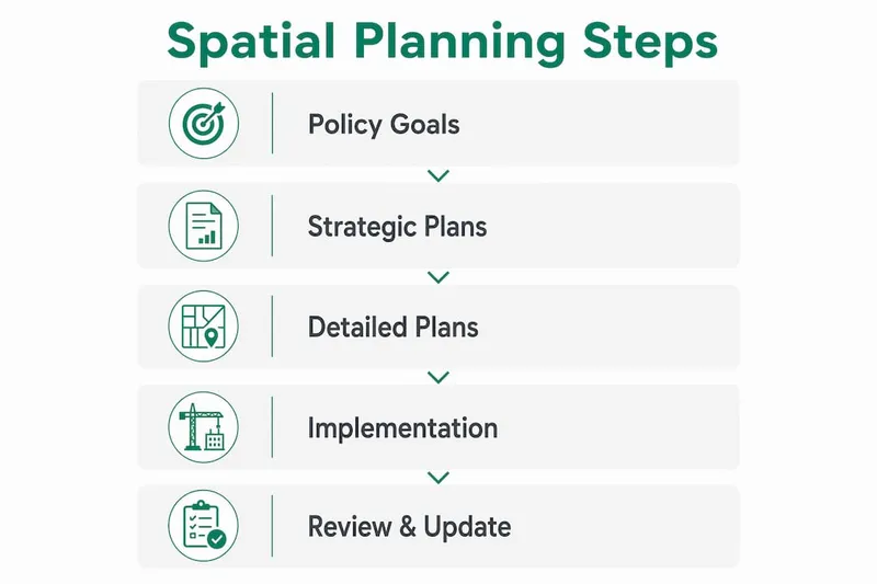
Spatial planning functions as a multi-level hierarchy where broad national strategies translate into detailed, site-specific local rules. This layered structure often surprises developers who expect a simple zoning map and instead find a complex web of policy coordination. Each tier of government plays a distinct role in shaping what gets built, where, and at what density.
The hierarchy works like this:
- National level: Government sets overarching targets for housing delivery, infrastructure investment, and environmental protection. These targets create the policy framework that all lower tiers must follow.
- Regional level: Regional plans interpret national targets and apply them to geographic areas, identifying growth corridors, transport hubs, and protected land.
- Local level: Local environmental plans translate regional guidance into specific controls for individual sites, including permitted uses, building heights, and setback distances.
The transition from strategic planning to detailed implementation follows this cascade, ensuring overarching policy coherence with site-specific regulation. A national housing target, for example, does not automatically grant permission to build anywhere. It must pass through regional allocation and then local zoning before it affects a specific plot of land.
Pro Tip: Before purchasing land or commissioning designs, check which tier of spatial plan governs the site. A regional plan may designate land as a growth area while the local environmental plan still restricts development pending a rezoning application.

Understanding this layered system is the first practical step for anyone navigating building permits and approvals in their local area.
What role does spatial planning play in sustainable development?
Spatial planning actively supports municipalities in meeting legally mandated net-zero and climate neutrality targets. It integrates energy, mobility, and land use planning through stakeholder collaboration and legal mandates. This makes it one of the most powerful tools governments hold for addressing climate change at a community level.
The practical steps through which spatial planning delivers climate outcomes include:
- Energy integration: Plans designate zones for renewable energy infrastructure, such as solar farms and district heating networks, ensuring these facilities are located where they cause least conflict with housing and nature.
- Mobility planning: By locating housing near public transport corridors, spatial plans reduce car dependency and lower transport-related emissions across entire communities.
- Green infrastructure: Plans protect and expand urban green spaces, wetlands, and tree canopy, which absorb carbon and reduce urban heat.
- Housing renewal: Spatial plans can direct investment into existing built-up areas rather than greenfield sites, reducing the carbon cost of new construction.
"Spatial planning is not just regulation; it is institutionalised collaboration integrating sectors like energy, mobility, and housing for holistic development." — Fedarene, IN-PLAN Project
Multi-stakeholder engagement is legally required in most jurisdictions before a spatial plan can be adopted. This means residents, businesses, environmental groups, and infrastructure providers all contribute to the final document. The result is a plan that reflects a broader set of community values than any single authority could produce alone. For individuals planning a new build, this process also creates the environmental impact assessment requirements that apply to larger developments in their area.
How do national traditions shape spatial planning approaches?
Definitions of spatial planning vary internationally but consistently involve processes to reconcile competing interests using formal regulatory tools. A 31-country comparative study shows that national traditions influence both regulatory instruments and procedural approaches in significant ways. What counts as a binding plan in one country may be only advisory guidance in another.
| Planning tradition | Regulatory character | Key instrument |
|---|---|---|
| Comprehensive integrated | Legally binding at all tiers | National spatial strategy |
| Land use management | Primarily local and site-specific | Local development plan |
| Regional economic | Growth-focused, infrastructure-led | Regional spatial framework |
| Urbanism tradition | Design-led, city-centred | Urban master plan |
Spatial planning covers both land-based and maritime domains and varies in terminology and implementation due to national legal and cultural contexts. Despite these differences, balancing competing land uses and integrating sectoral policies remain core objectives universally. A coastal development project in the Netherlands, for example, must satisfy maritime spatial planning rules alongside terrestrial ones. The same project in Australia would face an entirely different regulatory structure, even if the underlying goals are similar.
No single universal spatial planning method exists. Processes must fit the cultural, social, and ecological values specific to each region, as well as the democratic mandates of local institutions. This context-dependence is why planners and developers working across borders need to treat each jurisdiction as a distinct system rather than assuming rules transfer directly.
Pro Tip: If you are working on a development near a national boundary or in a coastal zone, check whether maritime spatial planning rules apply in addition to terrestrial ones. Overlooking this distinction can delay approvals significantly.
What practical implications does spatial planning have for property development?
Spatial plans determine permissible land uses and development density, directly affecting developers' property rights and permissions. Local environmental plans translate strategic targets into zoning and controls that apply to individual lots. This is where the abstract concept of spatial planning becomes very concrete for anyone planning a build or renovation.
The practical implications for you as a builder or developer include:
- Permitted use: The spatial plan for your site specifies whether residential, commercial, industrial, or mixed use is allowed. Building outside the permitted use category requires a rezoning application, which can take years.
- Density controls: Plans set maximum floor space ratios and building heights. These figures determine how many dwellings you can fit on a site and how tall they can be.
- Setback requirements: Spatial plans feed directly into property line regulations that dictate how close a structure can be built to boundaries, roads, and waterways.
- Infrastructure contributions: Many plans require developers to contribute financially to roads, schools, and parks when they increase the density of an area.
- Heritage and environmental overlays: Plans layer additional controls over sites with heritage significance or ecological sensitivity, restricting demolition or vegetation removal.
Municipalities use spatial planning to coordinate accessibility, liveability, and safety when locating new developments and infrastructure. Authorities assess all spatial planning aspects for decisions on business parks, housing estates, and transport projects. For an individual building a home, this means the council is not just checking your drawings against a single rule. It is assessing your proposal against a layered set of policies that reflect community-wide decisions made over years.
Understanding these controls before you design saves time and money. A proposal that conflicts with the spatial plan will face objections, redesign requests, or outright refusal. Checking the applicable local environmental plan at the outset is not optional. It is the foundation of any credible development strategy.
Key takeaways
Spatial planning is a multi-level public process that translates national policy goals into site-specific land use controls, shaping what can be built, where, and at what density.
| Point | Details |
|---|---|
| Layered governance structure | National, regional, and local plans each play a distinct role in controlling land use and development. |
| Climate integration | Spatial planning legally mandates net-zero and climate neutrality targets through energy, mobility, and green infrastructure. |
| National variation | Planning traditions differ significantly across countries, requiring context-specific approaches for each jurisdiction. |
| Direct development impact | Local environmental plans set permitted uses, density limits, setbacks, and infrastructure contributions for individual sites. |
| Dynamic, not static | Spatial planning is an ongoing institutional process, not a fixed zoning map, and evolves as policy priorities change. |
Spatial planning: more than lines on a map
Spatial planning is consistently misread as a static document. Developers pick up a zoning map, identify the colour of their site, and assume that settles the matter. In practice, the zoning map is the end product of a process that began years earlier at national government level and passed through multiple rounds of stakeholder consultation before reaching the local plan.
What strikes me most, having worked through planning processes across different contexts, is how much institutional knowledge sits behind a single planning decision. The council officer assessing your application is not just reading one document. They are weighing your proposal against a national housing strategy, a regional infrastructure plan, a local environmental plan, and potentially several overlays covering heritage, flooding, or biodiversity. Each of those layers was shaped by a different set of actors with different priorities.
The climate dimension has changed spatial planning more than any other single factor in recent years. Plans that once focused almost entirely on land use separation now have to integrate energy demand, transport emissions, and green infrastructure as core considerations. That shift has made spatial planning more complex, but also more consequential. A well-designed spatial plan can meaningfully reduce a community's carbon footprint. A poorly designed one locks in car dependency and energy inefficiency for decades.
My honest view is that individuals and small developers underestimate spatial planning at their peril. The time to understand the plan that governs your site is before you buy the land, not after you have commissioned drawings. The rules are not arbitrary. They reflect real community decisions about how a place should grow. Working with them, rather than against them, is always the faster and cheaper path.
— Azai
FAQ
What is the definition of spatial planning?
Spatial planning is a public sector process that influences the future distribution of people and activities across spatial scales. It coordinates decisions across national, regional, and local government levels to regulate land use and balance economic, social, and environmental goals.
How does spatial planning affect building permissions?
Local environmental plans, which are the local tier of the spatial planning system, set the permitted uses, density limits, and development controls for individual sites. A proposal that conflicts with these controls will require a rezoning application or risk refusal.
Why does spatial planning vary between countries?
National legal traditions, cultural values, and democratic structures all shape how spatial planning is organised and enforced. A 31-country comparative study confirms that planning approaches differ significantly even when the underlying objectives are the same.
What is the link between spatial planning and climate change?
Spatial planning is a primary tool for meeting net-zero and climate neutrality targets at the municipal level. It integrates energy, mobility, and land use decisions to reduce emissions and build climate-resilient communities.
Is spatial planning the same as zoning?
Zoning is one instrument within spatial planning, but the two are not the same. Spatial planning is the broader multi-level process that produces zoning maps and many other controls, including infrastructure plans, environmental overlays, and strategic growth frameworks.