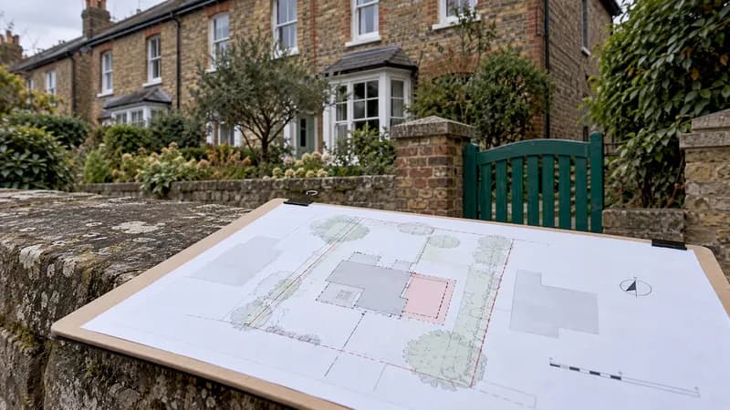
A site plan for a permit is a scaled, top-down drawing that shows your proposed work in relation to your property boundary, existing buildings and neighbouring streets. In the UK it is usually called a block plan, and most planning applications need it alongside a separate location plan. The detail below is UK-focused, because that is where the rules are most settled. Other countries ask for similar things in different units and formats.
TL;DR
- In England, a site plan (block plan) is normally drawn at 1:100, 1:200 or 1:500. A location plan sits at 1:1250 or 1:2500.
- Show the proposal against your boundaries, existing buildings, adjacent roads, access, parking and anything to be demolished, with a north point.
- The location plan is the "where", with a red line round the site. The site plan is the "what, exactly where".
- Your own council can add local requirements, so read its validation list before you submit.
- A clear, correctly scaled plan avoids the most common reason for an application being sent back unvalidated.
Table of Contents
- What a site plan is, and how it differs from a location plan
- When you need a site plan for a permit
- What your site plan should show
- Scale, north point and red line: the technical rules
- How to prepare a site plan, step by step
- Can you draw a site plan for free?
- Common reasons a site plan gets sent back
- Do you need a site plan outside the UK?
- Perspective: why we think planning should feel less like paperwork
- Keep your plans and budget in one place
- FAQ
- Sources
What a site plan is, and how it differs from a location plan
Think of the pair as a zoom lens. The location plan is the wide shot, the site plan is the close-up.
The Planning Portal explains that a location plan shows the proposal in its surrounding context, while a site plan or block plan shows the development in more detail. The same guidance notes that most planning applications require both, and that "site plan" is often used interchangeably with "block plan".
| Location plan | Site plan (block plan) | |
|---|---|---|
| Purpose | Shows where the site sits among surrounding properties and roads | Shows the proposed development against your boundaries and existing buildings |
| Typical scale | 1:1250 or 1:2500 | 1:100, 1:200 or 1:500 |
| Key marking | Site outlined in red, other land you own in blue | Existing and proposed buildings, boundaries, access |
| Must have | North point, identified metric scale | North point, identified metric scale |
The scales above come from the Planning Portal's guide to maps and plans. The Portal's FAQ adds that site or block plans are typically submitted at 1:200 or 1:500, so those two are the safe starting point for most house projects.
When you need a site plan for a permit
If you are applying for planning permission for an extension, a new dwelling, an outbuilding or a change that affects the footprint of your property, expect to supply one. Minor internal work usually does not need planning permission at all, though it may still need building regulations approval, which has its own drawing requirements.
A useful habit: before you draw anything, find your local planning authority's "validation requirements" or "local list". The Planning Portal is clear that local planning authorities may have their own requirements for a site plan or other specific plans, so checking their website first saves a rejected submission.
If you are planning a renovation and want a wider view of the paperwork, our renovation permit checklist for UK homeowners walks through the full set of documents, not just the plan.
What your site plan should show
Councils phrase it differently, but the core list is remarkably consistent. New Forest District Council's drawing standards describe typical content for a site or block plan:
- Existing and proposed buildings
- Adjoining roads, footpaths or rights of way
- Boundaries and boundary treatments (walls, fences, hedges)
- Hard surfacing such as parking areas and paths
- Trees, where relevant
- Buildings to be demolished
The Planning Portal adds the framing idea: the plan shows the proposed development in relation to the property boundary, including existing buildings, other buildings within the boundary and adjacent streets.
Make existing and proposed unmistakable
A planning officer should be able to tell, in two seconds, what is already there and what you want to add. Use a different line weight or hatching for new work, and label everything. Some authorities go further: the Shire of Carnarvon in Western Australia, for instance, asks for proposed buildings in a contrasting colour. Even where your council does not demand it, the habit makes your drawing easier to read.
Dimensions that matter
Show the distance from the new work to each boundary. This is where many first-timers stumble, because a drawing that looks fine to you may leave the officer unable to confirm the proposal sits where you say. Overseas rules show how seriously this is taken: Puyallup in Washington State asks for dimensioned property lines, setbacks, easements, service locations and driveways, and labels for structures as existing, proposed or to be removed.
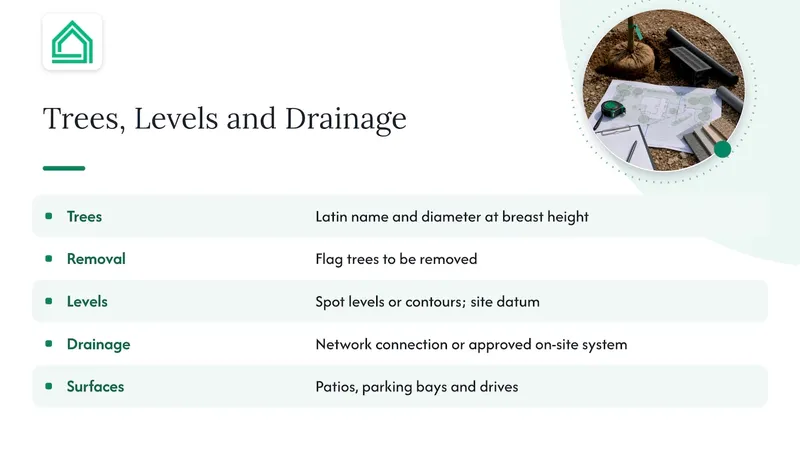
Trees, levels and drainage
UK householder applications often need only the basics, but larger or sloping sites attract more questions. Trees are a good example. In Bellevue, Washington, the city wants every tree shown with its Latin species name and diameter at breast height, and trees to be removed flagged. Whakatāne District Council in New Zealand asks for spot levels or contours and a site datum, plus drainage information, including connections to a network or approved on-site system.
Your UK council may not use those exact formats, but the thinking carries over. If your plot slopes, or your extension sits near a mature tree or a drain, show it and expect the officer to look for it.
Surfaces count too. New patios, parking bays and drives belong on the plan, and if you are still choosing between driveway and landscaping surfaces, settle the layout before you draw so that what you submit matches what you build.
Scale, north point and red line: the technical rules
Scale
Use a recognised metric scale and state it on the drawing. Per the Planning Portal, location plans are typically 1:1250 or 1:2500, and site plans 1:100, 1:200 or 1:500. Pick the scale that lets the whole site fit on the sheet while keeping the detail readable. If you print, check that a scale bar is on the plan so it survives resizing.
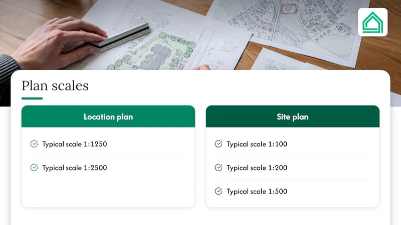
Scale is local too. Whakatāne shows its site plan at 1:200 with a north point, legal boundaries and building dimensions to boundaries, whereas Aurora, Colorado requires a uniform engineering scale of at least 1 inch = 40 feet. If you are reading this outside the UK, your council's checklist is the final word.
North point
Every plan should show north. It is a small thing, and one of the easiest omissions to make. New Forest District Council specifically advises using an up-to-date Ordnance Survey base or equivalent and showing north.
Red and blue lines
On the location plan, the Planning Portal says to outline the development site in red, and any nearby or adjoining land you own in blue. The red line must include all the land needed to carry out the work, which commonly means the access to the public road too. Keep the same boundary on every drawing in the set, so the documents agree with each other.
How to prepare a site plan, step by step
- Read the validation list. Find your council's local requirements and note anything beyond the national basics.
- Get an accurate base. Use an up-to-date Ordnance Survey base or equivalent, as councils such as New Forest advise. Your title plan helps with boundaries, though it is not always to scale.
- Measure the site. Record the boundary lengths, the footprints of existing buildings, and distances between them. Walk the plot with a tape or laser measure and a notebook.
- Mark the boundary and existing buildings. Include neighbouring structures that sit close to the line, and the adjoining road or footpath.
- Add the proposal. Draw the new building or extension in a clearly different style, with dimensions to the boundaries.
- Add the supporting detail. Access, parking, hard surfacing, trees, boundary treatments and anything to be demolished.
- Label and annotate. Scale, north point, a title, date and drawing number.
- Cross-check against the other drawings. Your floor plans and elevations must tell the same story as the site plan. Our guide to what first-time builders must check on drawings covers that consistency check.
- Export and review. Save in the format your council asks for, and look at it as an officer would, with no prior knowledge of your project.
Project size matters. Whakatāne's guidance notes that the size and complexity of a project often determine the level of detail and the extent of associated documents. A garden room needs a lean plan. A new house on a sloping plot needs much more.
Can you draw a site plan for free?
Yes. A site or block plan can be produced yourself from scratch, but it still has to meet the standards above: correct scale and orientation, accurate boundaries and the required surrounding features, and your council's local requirements. Free does not mean looser. Officers apply the same validation test to a hand-drawn plan as to a professionally prepared one, so accuracy is what counts, not the tool.
Common reasons a site plan gets sent back
- No scale stated, or a scale that does not match the drawing
- Missing north point
- A red line that leaves out the access route
- Proposed dimensions not tied to the boundary
- The site plan disagreeing with the floor plans or elevations
- Ignoring a local requirement that is on the council's own list
The pattern is the same each time: the drawing was fine as a sketch but not complete as a submission. Treat the council's checklist as your brief. If you reach inspection stage later, our permit inspection checklist helps you avoid repeat visits, and the owner builder permit requirements guide covers the first things to line up before you apply. Working on an older property? Our piece on historic home renovation permits explains why complete plans matter even more there.
Do you need a site plan outside the UK?
Almost certainly, though the name and trigger vary. Des Moines, Iowa, for example, uses site plan review for industrial, commercial or multi-family projects with three or more units per lot, and sends residential projects of two or fewer units per lot through a separate process. Green Bay, Wisconsin says its staff check site plans for compliance with the city's zoning ordinance, building code and comprehensive plan. Some places also ask for specific copies: Dawson Creek in Canada has asked for two stamped physical copies or one stamped digital copy on a complex building permit. The lesson is universal: find the local checklist first.
Perspective: why we think planning should feel less like paperwork
We built House A-Z for people who are doing this for the first time and feel the weight of it. A site plan looks like a single drawing, but it is really the point where your budget, your design and your permit all meet. If the boundary distances are wrong, the whole conversation with the council starts on the back foot.
What we see again and again is the chaos of juggling spreadsheets, PDFs and message threads. Our approach is to keep room layouts, product choices, costs and project management in one place, so that what you draw, what you buy and what you tell your contractor all agree. Our AI agents work in plain language and are designed to flag the kind of mistakes that get expensive later.
A good site plan is not about looking professional. It is about being clear. Get that clarity early, and the rest of the build gets calmer.
Azai
Keep your plans and budget in one place
Once your site plan is drafted, the next question is usually what it will cost to build what it shows. House A-Z brings budget tracking, room mapping, permit guidance and contractor collaboration into one interface. There is a free plan to start, Pro at €29 per month, and Enterprise from €99 per month for professional contractors and real estate firms; see the plans and pricing for what each includes, or meet the AI agents that turn your budget and preferences into suggestions.
FAQ
What is a site plan?
A site plan is a scaled drawing that shows your proposed development in relation to the property boundary, existing buildings and adjacent streets. In the UK it is also called a block plan. It is submitted alongside a location plan with most planning applications.
What scale should a site plan be?
For UK planning applications, site or block plans are typically drawn at 1:100, 1:200 or 1:500, with 1:200 and 1:500 the most common. Location plans use 1:1250 or 1:2500. Always state the scale on the drawing and include a north point.
What is the difference between a site plan and a location plan?
The location plan shows your site in its wider surroundings, with the application site outlined in red. The site plan zooms in to show the proposal, existing buildings, boundaries and access in detail. Most applications need both.
Can I make my own site plan?
Yes, as long as it meets the council's requirements for scale, orientation, accurate boundaries and surrounding features. Check your local planning authority's validation list before you submit, because councils can ask for extra detail.
Sources
- Planning Portal: Maps, plans and planning applications
- Planning Portal: difference between a location plan and a site plan
- New Forest District Council: Plan and drawing standards
- Shire of Carnarvon: Where to start
- City of Puyallup: How to draw a site plan
- City of Bellevue: Residential site plan
- Whakatāne District Council: Standard of documents and plans
- City of Aurora: Site Plan Manual
- City of Des Moines: Site plan review
- City of Green Bay: Site plan information guide
- Dawson Creek: Complex building permit checklist
- UK Planning Maps: free site or block plan